MOE scientists go high tech to measure algae
Who are those guys in waders down on our beach and why are they dipping strange flashlights into the water?
Simple. They’re government scientists and they’re studying the growth and volume of nuisance algae.
To better understand the increase of algae along the shoreline, Ontario Ministry of the Environment staff have started measuring algae both upstream and downstream from five key rivers and streams entering Lake Huron.
The work is being carried out by Dr. Ronald Griffiths, Ecologist, and Ryan Smith, a Surface Water Specialist with the ministry.
Streams transport various salts, nutrients and suspended solids that originate primarily on farm fields to the shoreline waters of the lake. This may contribute to growth of Cladophora, a green filamentous alga, and other algae that attach to rocks and solid objects in shallow waters.
Storms along the lake help scour algae from these surfaces and on-shore currents carry them to the shoreline. In some places this action results in unsightly, green "yuck" floating in the water or matted on the shore.
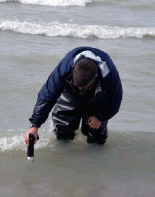
A Bentho-Torch, new technology from Germany,
was used to measure the abundance of algae on the nearshore sediments of Lake Huron.

A Bentho-Torch, new technology to measure algae, cyanobacteria and diatoms.
The torch is a waterproof spectrophotometer device that:
-
shines coloured lights onto the sediments
-
measures the reflected light, and
-
estimates the amount of green algae, cyanobacteria, and diatoms present.
In calf-deep water, the torch is placed on the bottom sediment at 10 random sites along a straight line and after a 30-second period, the torch provides information on the mass of greens, cyanobacteria and diatoms present.
Water samples are collected both upstream and downstream to measure the concentration of salts, nutrients and suspended solids.
Data gathered in the fall of 2011 confirmed that a greater concentration of algae occurred down-current of watershed tributaries as they entered the lake, compared to up-current.
Those results correlated with higher concentrations of phosphorus also found in down-current waters.
As best management practices are implemented within the area, gathering similar data will allow researchers to measure if and how much the ecosystem is benefitting cumulatively from the many individual projects being implemented to reduce the loss of soil and nutrients from agricultural lands.